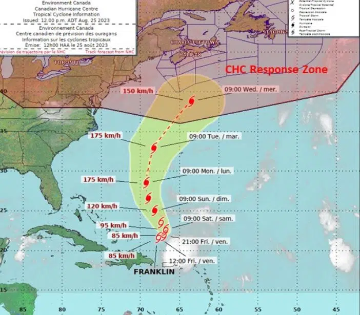
The Canadian Hurricane Centre released its inaugural bulletin on Friday at noon, shedding light on the evolving situation regarding Tropical Storm Franklin. The storm’s trajectory is projected to escalate it into a potent Category 2 hurricane while it charts a course to the west of Bermuda at the outset of the upcoming week.
Notably, the bulletin underscores that we are now standing within a five-day threshold before Franklin encroaches upon Canadian offshore waters. As per the bulletin, the prevailing prognosis indicates that Franklin is anticipated to veer notably south of Nova Scotia, its trajectory potentially brushing past southeastern Newfoundland. The bulletin emphasizes that the storm’s most turbulent segment is likely to remain over the open ocean.
Impacted by this impending weather system, the southern segments of the Atlantic Canadian marine districts are expected to face elevated risks of experiencing formidable winds and tumultuous seas originating from the storm.
Official projections illustrating the anticipated track and potential range of Franklin have been unveiled. This graphic depicts Franklin’s path as it bypasses Bermuda and heads toward the southern marine districts of Atlantic Canada, with the expected arrival scheduled for Wednesday of the forthcoming week.
The bulletin underscores the inherent variability associated with storm trajectories and advises the public to remain vigilant for updates over the weekend. The Canadian Hurricane Centre’s latest insights and advisories are accessible online.
Currently situated approximately 350 km north of the Dominican Republic, Franklin’s core is characterized by maximum sustained winds clocking in at approximately 85 km/h.
Presently, the storm’s northward advancement has come to a standstill; however, forecasts indicate that this stall will be temporary, with movement expected to recommence over the next 24 hours. Franklin has encountered westerly winds that have effectively dispersed its cloud cover eastward from the storm’s center. Despite this, the forecast remains consistent in anticipating the storm to intensify into hurricane status in the coming days, attributed to its traversal over oceanic waters that are suitably warm for such development.


